 |
| Ancient Kirkinitida |
|---|
In the third quarter of the sixth century BC (550-525 BC) Greek emigrants from Milet founded Kerkinitida - an independent slave-holding city-state and a democratic republic. The first mention of Kerkinitida is found with the ancient authors: Herodotus and others like Strobon, Adrian and Hekatae.
Herodotus, in the fifth century BC, twice mentions Kerkinitida in his work ‘History’ (in book 4). In the first passage Herodotus writes that the Hipakrir river “crosses the Scythian-nomad region and then enters the sea near the city Kirkinitida." In his second mention, he describes the land of the Scythians, and states that it "extends to the city named Kirkinitida".
The exact location of Kirkinitida was not known for a long time. The prize for the first to uncover its location belongs to a member of the archeological commission managing the excavation of Chersoneses, L. Moyeceevu, who, on the basis of excavations in Evpatoria (during 1916 to 1918) proved the site was ancient Kerkinitida on Cape Karantin. |
|  | | |
|
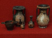
Approximately seventy years after its founding, when the town’s population had increased due to natural growth and the acquisition of slaves, defensive walls were built up. Town development was done by plan. A small city even for those times, the population of around 2,000 found itself living in an important trading center, with trade and economic relationships to Hellenic cities and cities in Asia Minor and the north Black Sea region. Kerkinitida had extensive trade with almost the entire ancient world. In city dealt in expensive wine and olive oil, sweet oil, dishes and luxury items. From the colony went grain, salt, salty fish and to Greece went slaves, acquired from the Scythians. From the 5th century BC, the town minted its own copper coin.
The main business of Kirkinitida’s inhabitants was clearly husbandry: here they grew wheat and grapes, pressed wine, breed cattle and mined salt. In addition the men caught fish. The city had its own handicraftsmen: carvers and foundry men. Stonemasons were so skillful here that mortar was not needed in the construction of houses.
In the middle of the 5th century BC the town covered 5.3 hectares and had a population of 1800. It was a typical city-state with its own political power and its own economy. Beyond the defensive wall lay the communal lands of the city and private plots of its citizens. Including Kirkinitida’s entire agricultural region, its area was approximately 20 square kilometers, i.e. nearly 40 times greater than the city itself. The fertile lands around Kerkinitida became the reason the city lost its political and economic independence. The agricultural lands attracted the attention of its neighbors, first of all Chersoneses (modern Sevastopol).
Biological studies show that the area of Evpatoria was not, as it is now, steppe scorched by the sun. Multiple streams and rivers encircled many forests of oak, elm, alder, poplar, maple and juniper trees. Pine groves were not scarce. In the forests there were many different wild animals for hunting: deer, wild boar, bear, wolf, hare and badgers, etc.
Economic pressure from Chersoneses, whose own land limited the town’s agricultural expansion, forced Kirkinitida’s inhabitants to consent to an alliance with it. This occurred at the turn of the third century BC. Kirkinitida’s inhabitants enjoyed the full rights of citizenship in the political plan of Chersoneses while the city lost its economic rights to free trade. At the same time, Kerkinitida was second in Tavria in size and importance after Chersoneses.
The Greeks and later the Genoese were able to transform the town into an important trading center, contending even with queen of Crimea: Feodosia (Kafa). Venetian and Genoese archives are full of descriptions of the wealth and trading power of Evpatoria and its inhabitants. Genoese colonies in the north Black Sea region and consolidated trading centers of Genoese merchants existed everywhere in the thirteen to fifteenth centuries. There was great trade with the countries of Western and Eastern Europe, including the Russian lands.
Life in Kerkinitida was never peaceful. In the fourth to third centuries BC on the peninsula’s plains appeared the late-Scythian kingdom and the main Scythian city of Neapol (in the area of present-day Simferopol). There is evidence of this city around present-day Simferopol in the form of ruins: fortifications, dwellings and economic buildings, mausoleums, stone vaults with paintings and other items. This strong Scythian state occupied an extensive territory from the lower reaches of the Dniepro River in the north to the Crimean mountains in the south and from the coast of the Black Sea in the west to Feodosia in the east.
The relations of the Hellenes with the Scythians were not friendly. It was basically unceasing war between the two. At the turn of the second century BC the city endured its next upheaval: its seizure and destruction by Scythians. Settlements in northwest Crimea were subjected to assault from the first third of the third century BC to the turn of the millennium. The war between Chersoneses and the Scythians was protracted. The republic had to seek help from the Bosporian Kingdom, located on the Kerch and Taman peninsulas. The Tsar of Bospor, Mitridat VI Evpator (Evpator - a moniker for the Pontic Tsar (from Greek meaning. – ‘noble’)) ordered the military leader Diophant to assist Chersoneses.
The directive (at the end of the second century BC) in honor of Diophant, the ‘military leader of the Pontic Tsar Mitridat VI’ kept in the Hermitage in St. Petersburg reported on the liberation of Kirkinitida: "The Scythians revealed their innate treachery and pulled away from the Tsar and changed their position and for that reason Tsar Mitridat Evpator once again sent Diophant’s army even though winter was coming. Diophant with is own soldiers and his strongest men advanced right up to the Scythian fortresses and although delayed by bad weather and the tricky seaside terrain, seized Kirkinitida." During one of the campaigns Diophant founded a fortress named by Evpatorion in honor of Mitridat Evpator. Present-day researchers located the ancient settlement as it was uncovered at the location of Kara-Tobe (now, Prebrezhnoye).
Liberated in the second century BC, Kerkinitida was not able to rise to its former level and completely ceased to exist at the turn of the millennium. Later Scythians once again seized Kerkinitida and approached Chersoneses but were again routed by the military leader Diophant. At the turn of the new millennium Mitridat VI Evpator suffered a defeat in his war with Rome and roman legions entered Crimea. Chersoneses became their reference and support point on the peninsula.
In connection with the weakening of the Roman empire, the Scythians returned again and lived here, probably until the third century when city ceased to exist as a result of Goth invasions (a Germanic tribe), migrating south from the Baltic coast. The Goths destroyed everything in their way, including Kirkinitida. This probably ended the ancient history of Kirkinitida. It seems that it is in connection with this Goth conquest of Crimea in ancient times that high-ranking Germans (in the twentieth century) considered Crimea a special territory. Crimea had not yet been completely captured by Hitler troops when already at the end of 1941 Rosenburg suggested to Hitler the renaming of Crimea to Gotenland and changing Simferopol to Gotenburg.
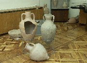
Evpatoria’s present-day buildings on Cape Karantin (now the territory of the Ukrainian Health Ministry sanatorium) conceal from history the remainders of the ancient city. In the area of Evpatoria’s town theater and its adjoining streets an ‘obituary’ was found - a graveyard of Kirkinitida’s inhabitants. Curious tourists can see just a small part of the town - the remainder of the southern defensive wall at the beginning of the Gorky Embankment and small part of Kirkinitida’s northwest suburb on Duvan Street. At one time the defensive walls reached to a height of six to eight meters and were three to five meters thick, with high towers installed every 150 meters. Walls enclosed the city in a three-kilometer semi-circle that opened to the sea. To the west, north and east behind the wall was a deep (up to 9 meters in depth) stone-lined trench, filled with sea water. | |